Google has rolled out several new transit features to Google Maps on iOS and Android that aim to help users travel safely as lockdown measures gradually ease in some countries following the coronavirus pandemic.
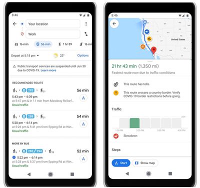
The latest version of Google Maps alerts users whose travel will be impacted by COVID-19 restrictions, including requirements like wearing a mask on public transport and whether a chosen route has checkpoints. The update was detailed in a Google blog post:
Getting from A to B can be more complicated these days. Because of COVID-19, it’s increasingly important to know how crowded a train station might be at a particular time or whether the bus is running on a limited schedule. Having this information before and during your trip is critical for both essential workers who need to safely navigate to work and will become more important for everyone as countries around the world begin to reopen.
While users of public transport will get crowd-sourced information on how busy services are, drivers will receive alerts about checkpoints and restrictions on their route, such as when crossing national borders, on the directions screen and after starting navigation if a route is affected by restrictions.
Google says the transit alerts are rolling out in Argentina, Australia, Belgium, Brazil, Colombia, France, India, Mexico, Netherlands, Spain, Thailand, United Kingdom and the U.S. where it has information from local transit agencies, with more coming soon.
In addition, users navigating to medical facilities or COVID-19 testing centers will get alerts reminding them to verify eligibility and facility guidelines to avoid being turned away or causing additional strain on the local healthcare system.
Starting this week, alerts for medical facilities will be available in Indonesia, Israel, the Philippines, South Korea, and the U.S., while testing center alerts will also be available in the U.S. Alerts are based on authoritative data from local, state, and federal governments or from their websites.
Google Maps can be downloaded from the App Store for free. [Direct Link]


Top Rated Comments
(I am not being sarcastic). Just curious why my home country gets preferences over something like Germany